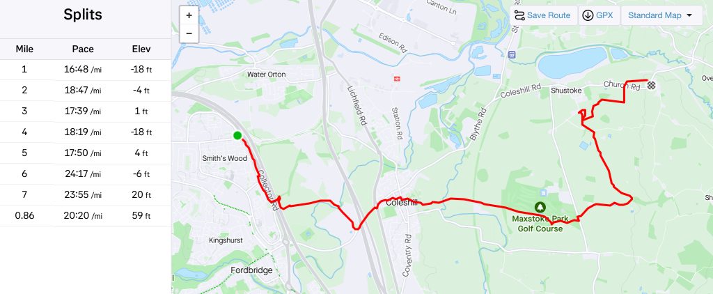
After another day at work, I reckoned that if I got home in time, I could walk to The Griffin by walking about seven miles part of which would be off-road.
I got away by four and for some reason, chose to go via Bordesley which, luckily, was a lot quieter than expected.
I arrived home just a tad before half four, went through the logistics with Sue (pick up at seven), changed and was out of the door by a quarter to five. Plenty of time.
I made my way, via Coleshill Manor, to Coleshill, crosssing the high street and making my way through the church grounds and down to the river.
At the entrance to the church there is aninformation boards that has been hidden by ivy for quite a while and are now visible again.
Why did I mention the boards? Because, to find a nearby geocache you need some numbers of this board. I took a photo and will give the cache another go soon.
Down at the river, it is crossed by what I dubbed the Bridge of Doom as Gabby is quite spooked by it when ever we try to cross. The council appear to be doing some work on said crossing as there are Heras fence panels attached to it.
It was already dark so I was walking by the light of my head-torch and not much else.
I followed, just about, the public footpath through the golf course emerging onto Castle Lane. After a few metres I left the road to follow a track towards Dumble Farm.
Just before the farm, the footpath veers off to the left before splitting with one path going back to Shustoke and the other through Dumble Wood and eventually popping out at The Griffin.
Both options involve crossing fields with the later, usually, a lot muddier. Witht his in mind I chose the one to Shustoke.
I soon realised my error as the next field was very overgrown and my promising pace dropped like a stone having to fight through the undergrowth.
Eventually, I got to better terrain and using an OS map on my phone took the route of the footpath although there was no evidence of it open the ground. I cross Moat House Farm Lane and followed a path I have used many times before except tonight.
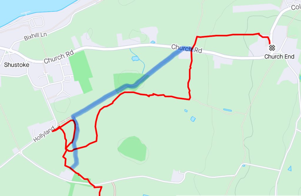
On the map, the blue line represents the path I should have been, and initially throught that I was, following.
After a while, I could see where I should be but was on the wrong side of an impenetrable hedge so spent a good ten minutes trying to get to the other side before giving up. I knew there were other paths roughly leading the way I wanted and eventually popped out onto Church Road from where it was but a short walk to The Griffin.
Sue had been waiting for me in the pub’s carpark and due to my rubbish navigation I turned up about twenty minutes later than anticipated.
As we were there, we popped inside where I had a pint each of Oakham 3 witches and a jar of Dark Star American Pale Ale.